When we first lived in the house (1961), there was a windmill operated well with several large tin reservoirs (and an electric pump to back up the decrepit windmill). The windmill itself was a metal framed thing that rose about 50 feet in the air. We used it water the garden for a year or so because at that time we had a gardener who kept it running, but within a few years, it was no linger operating.
Inside the house - in the basement, under one of the front rooms, was a cistern for house use. It was essentially a cement room. Attached to it, accessible from the basement was a hand pump - a huge wooden handle about 3 feet in length. This would pump water to the attic, where there were several barrels that fed the house by gravity. This system was operational when we moved in but because the house also had "city" water, it was never used much.
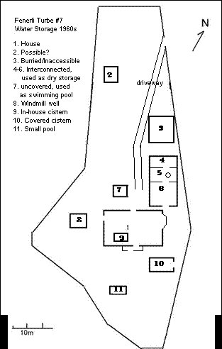
The grounds (the term "garden" above be-littles the size) included a warren of cisterns, most of them not holding water during the 60s-90s when we lived here. (Refer to the map)
Number 2 on the map may not have been a cistern. In the 60s, there were 4 crumbling walls of some kind of structure. Immediately to its west, there was some kind of an underground water source that would seep downhill toward the house, so this could have been water storage.
Number 3 was buried and more or less inaccessible. Above it was the back edge of what was once (so we heard) a tennis court. Someone had dug a rather uninviting crawl-hole opening that was covered by an overgrown blackberry bush. It would appear that the back (south) end of this one abutted Number 4.
4, 5 and 6 were used as dry storage. Actually, 4 and 5 were only accessible if you crawled through a 2 foot high tunnel. The celling of number 5 was topped with a marble well-head.
Number 7 was a 10' x 10' x 10' uncovered cistern that we once or twice scrubbed and used as a swimming pool of sorts.
The windmill/well system was located at number 8.
The inside/home cistern is number 9.
Number 10 was accessible from a hole in the east side of a wall. The map doesn't show that the property had multiple "layers". This cistern was underground, but the property landscape layering was such that the entrance on the east side was 6 feet up from the lower layer at its east edge.
Number 11 was a small abandoned pond.
Ground piercing sonar would probably uncover more.